Digital Orthomosaic
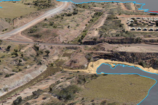
Our Digital Orthomosaic service delivers a bird’s-eye view of your project area with unparalleled precision. We capture high-resolution imagery and georeference it, creating a seamless, detailed map of your site. This comprehensive overview serves as a valuable foundation for project planning and execution. Whether you’re in construction, agriculture, or environmental monitoring, our Digital Orthomosaic is a management vital tool.
2D and 3D Digital Terrain Models
PSAH Drone Services goes beyond imagery. Our 2D and 3D Digital Terrain Models provide in-depth terrain analysis to help understand the topography of your site with survey grade accuracy. Analyse slopes, contours, and elevation changes to inform critical project decisions. Whether you’re designing infrastructure, optimising land use, or planning excavation, our terrain models give you the insights you need.
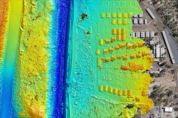
Elevation Models
Accurate elevation data is essential for various industries, from urban planning to flood risk assessment. PSAH Drone Services offers Elevation Models in convenient GIS data sets. Access precise elevation data that is crucial for accurate planning and execution. Make data-driven decisions that enhance project outcomes.
What Is a Drone Survey?
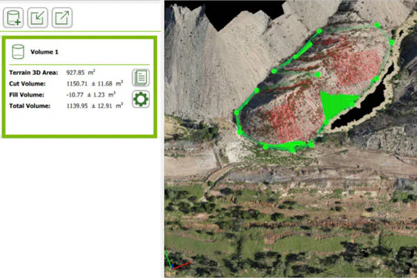
A Drone Survey involves the use of state-of-the-art drones equipped with advanced sensors, such as LIDAR payloads, RGB, or multispectral cameras. These drones capture comprehensive data by photographing the ground from various angles, with each image tagged with precise coordinates. Our photogrammetry software processes this data to create geo-referenced orthomosaics, 3D models, and elevation models. This information allows us to extract volumetric measurements and high-accuracy distances.
Advantages of Drone Surveying and Aerial Mapping
- Accurate and Reliable Data: A single drone flight can produce thousands of measurements, each containing 3D geo-data in formats like point clouds, DTM, contour lines, DSM, and orthomosaics.
- Expedited Data Collection: Aerial surveying drones efficiently capture large amounts of survey imagery and data, making them ideal for complex projects and quantity reporting.
- Access to Inaccessible Areas: Drones can access areas that are typically unreachable, such as steep slopes or harsh terrains unsuitable for traditional methods.
- Efficient Progress Monitoring: Drones enable remote project progress monitoring, enhancing efficiency and safety.
Precision and Accuracy
We pride ourselves on delivering survey grade GIS outputs with centimetre-level accuracy. Our high-resolution maps and survey data typically have a resolution between 1-3 centimetres per pixel (1-3cm GSD). The 3D terrain models we generate, including Digital Surface Models (DSM) and Digital Terrain Models (DTM), offer horizontal accuracy of approximately 50mm and vertical accuracy ranging from 50-80mm.